Flying the Florida Keys
|
|
It actually cost a little more to fly the RV down to the Keys than it would have for Lynnette and I to fly Southwest to Fort Lauderdale and rent a car. But I wanted to have my plane with me in the Keys so I could do some scenic flights. I'm sure glad I did. On our second day I took Ellen for a scenic flight from Marathon to Key West and back. Then Bruce took me on a scenic flight from Marathon to Key West and back. It was a perfect day for flying, weather-wise.
Here we are approaching Summerland Key where we were staying.
|
| |
 |
|
|
Boaters hanging out at one of the hundreds of Keys.
|
| |
 |
|
| The water was as beautiful as anything I saw in the Bahamas last year. |
| |
 |
|
|
Looking down at Key West Naval Air Station. I had no idea it was so large. There were probably 50 jets on the ramp. I flew down here once on a P-3. For official business, of course.
|
| |
 |
|
| Approaching Key West with Key West International Airport visible at bottom. |
| |
 |
|
| A good look at the Key West waterfront with a big cruise boat, medium cruise boat and U.S. Navy Arleigh Burke class Destroyer tied up. I did not see a single Officer or Sailor while we walked around Key West the next day. |
| |
 |
|
| Duval Street is easy to see in this picture if you know where to look. |
| |
 |
|
|
A little private airstrip between Marathon and Key West.
|
| |
 |
|
| I had to make sure we kept clear of this radar-carrying blimp the U.S. Navy uses to look for drug smugglers. |
| |
 |
|
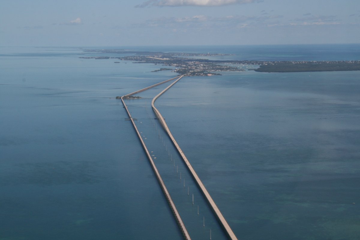
| The famous Seven Mile Bridge was too long to capture in one picture. The bridge on the left is the old one, no longer used, and now called the Florida Keys Overseas Heritage Trail. That little island is Pidgeon Key. We are heading east. Marathon airport is visible in the distance, top center. |
| |
 |
|
| A good look at Summerland Key. The red arrow points to the house where we stayed. The private airport community runway is very visible from the air, invisible from the Overseas Highway (A1A). |
| |
 |
|
|
Looking south.
|
| |
 |
|
| Looking East. |
| |
 |
|
|
The water is very shallow so they dredged paths for boats, plainly visible with the dark green color.
|
| |
 |
|
| More Islands in the Sky. |
| |
 |
|
| Bahia Honda State Park and the old Bahia Honda Bridge. |
| |
 |
|
| |
| It's funny how you get used to something. On the first flight with Ellen, I was stunned by the beauty of what I was seeing. On the second flight with Bruce, it was more like "Oh yeah, I've seen that. Yeah, it's beautiful. Do you have anything to eat?" |
| |
 |
|
|
Approaching Marathon Airport. Lynnette and Ellen were down on Sombrero Beach -- red arrow points to it -- waving to us.
|
| |
 |
|
| |
| Close-up of Sombrero Beach which is a great sunset viewing spot. A nice beach too., |
| |
 |
|
| |
| Marathon Airport looking east. |
| |
 |
|
| |
|
|
|
|
|
|